
Waterfront development gives Newbiggin Reborn a structured way to turn coastal protection into public access, local trade, environmental care, and long-term civic value. The approach treats the bay as a living edge where homes, businesses, heritage, tourism, and climate risk meet. Newbiggin already has a strong foundation through beach recharge, an offshore breakwater, the promenade, and the Maritime Centre.
Integrated Planning For Waterfront development And Coastal Form
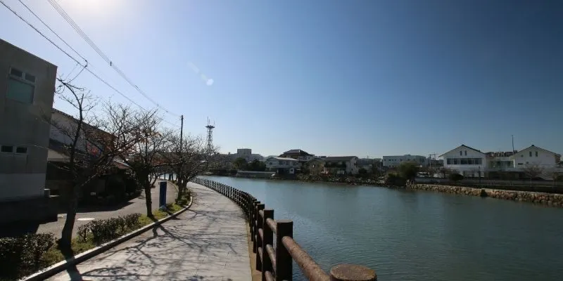
A strong waterfront plan begins by reading land, water, streets, heritage, and public movement as one system. Newbiggin’s seafront has visitor appeal because the bay links the beach, promenade, Church Point, the Maritime Centre, and views toward the offshore sculpture. Planning should protect public access while guiding where cafés, events, seating, drainage, and parking can operate without conflict. The first design stage can map 10 priority nodes, including arrival points, viewing areas, accessible routes, service zones, and spaces for small community events.

Geographic Position And Property Value Through Waterfront development
Waterfront location can increase property and commercial value when access, safety, views, and public realm quality improve together. However, value growth should not be measured only through private land prices or seasonal visitor numbers. Newbiggin needs indicators such as vacancy changes, footfall, dwell time, household satisfaction, and business confidence. A balanced plan can protect residents from overcommercial pressure while making the seafront more attractive for responsible investment.
Converting Former Port And Storage Areas
Some waterfronts contain old storage yards, working edges, or underused service spaces that weaken public connection to the water. Newbiggin’s history as a fishing and maritime settlement means reuse should respect practical working heritage rather than erase it. Small workshops, interpretation spaces, guided activity bases, and flexible community rooms can give older edges new purpose. The design should avoid luxury-only conversion because regeneration loses trust when local users feel displaced.
Green Mobility Links Along The Shore
A connected route should make walking, cycling, bus access, parking, and wheelchair movement easier without turning the coast into a traffic corridor. Wayfinding can show travel times from car parks to the beach, Maritime Centre, Front Street, toilets, shops, and heritage points. Waterfront development should prioritise low-speed movement and clear pedestrian priority near the busiest viewing areas. A practical target is to test all main routes with disabled users, families, older residents, and traders before construction drawings are finalised.
Open Park Strips For Public Water Access
Open park strips can provide rest, shade, stormwater storage, and safer access to views. They should include salt-tolerant planting, seating edges, litter points, lighting, and space for informal gatherings. In exposed coastal weather, planting must be selected for wind, salt spray, drought, and low soil depth. Park design should support public enjoyment while keeping sensitive edges protected from trampling and erosion.
Sustainable Architecture For Views And Wind
Buildings and shelters should frame sea views rather than block the public from the waterfront. Orientation can use natural ventilation, wind screening, solar gain, and sheltered entrances to improve year-round comfort. Materials should withstand salt spray and require realistic maintenance budgets, not just look attractive at opening. Design review should test how structures appear from the promenade, beach, inland streets, and elevated viewpoints.
Technical Infrastructure For Waterfront development And Climate Adaptation
Technical resilience must be planned before public spaces are widened, paved, planted, or promoted. Newbiggin’s coastal setting faces wave exposure, drainage pressure, wind, salt, and storm-related disruption. The earlier coastal protection scheme shows that hard and soft measures can work together when engineering is coordinated. Future infrastructure should combine reinforced edges, raised levels, smart drainage, ecological recovery, and monitoring systems.
Bank Reinforcement And Erosion Control
Edge reinforcement should respond to actual erosion patterns, ground conditions, and the role of existing coastal defences. In some areas, revetments, wall repairs, or reinforced foundations may be needed to protect paths and public assets. Waterfront development should use surveys before selecting hard materials, because unnecessary concrete can reduce visual quality and habitat value. Repairs should include inspection records, material specifications, and a maintenance owner from the start.
Raised Levels And Tide Defence Planning
Finished ground levels should consider future sea-level scenarios, storm surges, wave overtopping, and safe access gradients. Raised routes can protect users during high-water events while keeping the waterfront open for everyday use. Hidden walls, shaped seating, and planted edges can provide defence without creating an intimidating barrier. Designers should publish the assumptions behind level changes so residents understand why some areas rise or change shape.
Smart Urban Drainage In Waterfront development
Drainage must manage rainfall, high tides, sand movement, and blocked gullies after stormy weather. Smart systems can include sensors, maintenance alerts, permeable surfaces, overflow channels, and rain gardens where space allows. Waterfront development should set inspection triggers before autumn storms and after major rainfall. Public reports can show cleared drains, repaired outlets, and areas needing redesign.
Ecological Recovery Along The Water Edge
Ecological recovery should strengthen biodiversity while keeping public access practical. Suitable planting, rock-pool interpretation, water-quality checks, and habitat-sensitive maintenance can make the edge more educational. The bay already supports visitor interest through marine wildlife, the beach, and coastal views. Any ecological scheme should record baseline conditions before claiming improvement.
Public Private Models For Waterfront development Management
Funding and management need clear agreements because waterfront assets often involve councils, businesses, landowners, community groups, charities, and private operators. A public-private model can support cafés, events, maintenance, interpretation, lighting, and visitor services if responsibilities are visible. Contracts should define who pays, who repairs, who insures, who cleans, and who reports performance.

A balanced partnership should protect public access while allowing local enterprise to grow. Waterfront development can support markets, guided tours, heritage activity, small food offers, water-edge events, and educational programmes linked to the Maritime Centre. Suggested targets include 20 supported local businesses over three years, 15 percent off-season footfall growth, and two public performance updates each year.
Conclusion
Waterfront development gives Newbiggin Reborn a practical route for linking coastal access, climate adaptation, public space, responsible investment, ecology, and local economic confidence. The strongest plan will combine technical evidence with accessible design, green mobility, drainage capacity, heritage reuse, and transparent public-private management. Success should be judged through maintenance records, resident feedback, business performance, access audits, and environmental monitoring rather than promotional renderings.