
Beach nourishment explains how Newbiggin Reborn can maintain a living shoreline while protecting homes, public space, recreation, and local visitor value. The method adds compatible sand to an eroded coast instead of relying only on hard walls. At Newbiggin Bay, historic records show severe sand loss, clay exposure, and pressure on sea defences before major intervention. The approach links engineering with ecology, safety, tourism, and long term monitoring.
Beach nourishment Solutions For Newbiggin Coastal Protection
Newbiggin needed a practical response because its bay had lost much of the natural buffer that once softened wave impact. Records before construction described mining subsidence, erosion of clay beneath the sand, and a possible further two metre beach level reduction over ten years. The completed scheme brought new material into the bay while using an offshore structure to keep the restored shoreline stable.
Sediment Loss Before Beach nourishment
The coastline had not simply looked tired; it had lost material that performed a protective function. When beach height drops, waves can strike sea walls more directly and increase pressure during storms. The reduced sand cover also affects recreation because exposed clay and uneven surfaces make the bay less welcoming. Understanding that technical problem helps explain why a large scale sediment strategy was required.
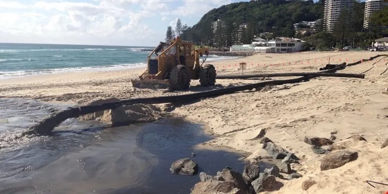
Artificial Sand Spraying And Placement Mechanics
The operational method relied on dredging, pumping, and controlled spreading across the beach profile. A specialist vessel drew sand from a licensed source near Skegness before connecting to a pipeline running about 1.5 kilometres into the bay. Around 300,000 cubic metres were pumped ashore in about three and a half weeks. Beach nourishment then required shaping so the new profile could absorb waves and support safe public access.
Sand Compatibility For Colour And Grain Size
Material selection matters because imported sediment must behave like a usable beach rather than a loose construction fill. Engineers should compare grain size, colour, shell content, compaction, drainage, and movement under local wave conditions. The Newbiggin scheme used 500,000 tons of new sand, giving the restored bay a meaningful recreational surface. Poorly matched sediment could move too quickly, look artificial, or create maintenance problems.
Safety Buoys And Construction Zone Mapping
Work zones need clear boundaries because dredging, pumping, machinery, tides, and visitor movement can create overlapping risks. A construction map should mark exclusion zones, pipeline routes, viewing areas, beach access, emergency points, and contractor routes. Buoys, barriers, notices, and daily updates help residents understand which spaces are restricted. Beach nourishment becomes safer when the public sees practical guidance before entering the seafront.
Noise And Fine Sediment Mitigation For Residents
Construction can affect nearby households through engine noise, vibration, vehicle movement, lights, and short term water cloudiness. Mitigation should include working hour controls, quieter equipment where possible, complaint logging, and clear explanations of temporary disturbance. Sediment monitoring can show whether fine material disperses within acceptable limits. Residents are more likely to tolerate disruption when managers publish updates and respond quickly.
Environmental Impact And Beach nourishment Performance
Environmental assessment must examine the bay as a dynamic system rather than a decorative shoreline. Sand placement can disturb seabed organisms, water clarity, birds, and intertidal habitats if timing and material controls are weak. At Newbiggin, the wider defence strategy also used an offshore breakwater, rock, and concrete armour to reduce energy and retain the new beach.

Wave Energy Absorption Through Beach nourishment
A wider beach absorbs energy before waves reach hard defences, reducing direct impact on walls and promenade assets. The new profile works as a sacrificial buffer that can shift, settle, and recover after ordinary weather. During storms, however, managers must check whether erosion concentrates near access points or structure edges. Inspections after major events help decide whether reshaping or selective topping up is needed.
Seabed Habitat Change And Native Species
The seabed community can change when new material covers existing sediments or when turbidity rises during pumping. Monitoring should examine invertebrates, birds, rock pool quality, and nearshore water conditions before and after works. A staged approach allows sensitive seasons to be avoided where ecological evidence supports restrictions. The goal is not to freeze nature, but to reduce unnecessary harm while protecting the town.
Profile Surveys After Large Storm Seasons
Regular surveys should measure beach height, slope, width, grain movement, drainage, and exposed clay after severe weather periods. Fixed profile lines every six months would create comparable evidence for engineering teams and residents. Drone images, ground photographs, and tide referenced measurements can make technical findings easier to explain. Beach nourishment works best when monitoring data directly shapes the next maintenance decision.
Supporting Structures That Retain Sand
The offshore breakwater is central because waves and currents would otherwise remove new material faster. Newbiggin’s scheme included a structure around 200 metres long and used about 60,000 tons of rock and concrete armour. Interlocking units dissipate wave energy while helping the restored beach stay within the bay. Beach nourishment therefore becomes more durable when soft sediment work is paired with carefully designed retention.
Natural Beach Form And Beach nourishment Value
A nourished shoreline should still feel like a beach, not a disguised engineering platform. Shape, colour, texture, access points, views, and recreational space all influence whether residents accept the change. Newbiggin’s renewed bay supports walking, photography, family visits, public events, education, and tourism connected to the Maritime Centre and offshore artwork. Keeping the form natural helps the town protect itself without losing its coastal identity.
The economic meaning reaches beyond summer leisure. A stable beach can increase dwell time, support cafés and shops, improve confidence for events, and give schools a practical outdoor learning space. Suggested local targets could include annual coastal education for 500 residents, 15 percent growth in off season promenade use, and two public monitoring updates each year. A public Beach nourishment dashboard can show whether those targets remain realistic. These targets should remain evidence based so regeneration avoids exaggerated claims.
Conclusion
Beach nourishment gives Newbiggin Reborn a balanced method for protecting the coast while preserving the natural shape, public use, and economic appeal of the bay. Its value comes from compatible sand, careful pumping, environmental safeguards, safety planning, reliable surveys, and supporting structures that reduce material loss. The completed Beach Recharge Newbiggin works show that large scale sediment renewal can transform a vulnerable shoreline when monitoring continues after construction.