Coastal sediment analysis gives Newbiggin Reborn a scientific way to understand how sand, clay exposure, currents, waves, and engineered structures shape the bay. The topic matters because beach material is not static; it moves, settles, thins, and sometimes disappears after storms. Historic evidence from Newbiggin showed serious loss of beach height before major protection work began.
Managing And Analysing Coastal sediment Around Newbiggin
Newbiggin Bay needed detailed material management because the beach had lost much of the surface that once reduced wave impact. Before intervention, records described mining subsidence, clay erosion beneath sand, and potential further lowering of the beach. The later coastal scheme brought around 300,000 cubic metres of recharge material into the bay and paired it with an offshore breakwater.
Geological Makeup And Beach Material Classes
The beach profile includes sand placed for defence, underlying clay, nearshore deposits, and harder protection materials around engineered structures. Each layer affects drainage, compaction, wave response, and public safety in different ways. Engineers should classify material by grain size, colour, shell content, moisture, density, and contamination risk. This classification helps managers decide whether a change is normal seasonal adjustment or a warning sign requiring repair.
Sources And Longshore Transport Mechanics
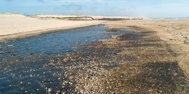
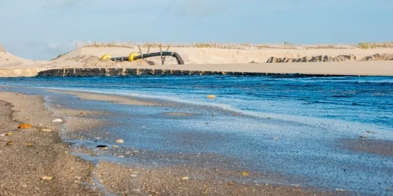
Coastal sediment reaches and leaves a bay through currents, wave angle, tides, storm surge, and human intervention. Newbiggin’s replenishment material came from a licensed area near Skegness before being delivered through a pipeline into the bay. Once placed, sand can move alongshore, offshore, or toward sheltered pockets depending on daily energy conditions. Understanding these pathways prevents managers from assuming every visible change means failure.
Wave And Tide Effects On Sand Distribution
Waves sort particles because heavier grains settle differently from lighter material during repeated swash and backwash. Tides also change where energy concentrates, especially near access points, structure edges, and shallow channels. Coastal sediment surveys should therefore compare low tide, high tide, calm weather, and post-storm conditions. This approach creates a realistic picture of change rather than one snapshot taken on a convenient day.
Erosion And Declining Natural Sediment Volume
Erosion becomes serious when natural replacement cannot match material leaving the bay. At Newbiggin, the earlier decline exposed hard layers and increased pressure on sea walls and public structures. Coastal sediment loss can also reduce amenity value because uneven surfaces feel less welcoming for families, walkers, and visitors. Tracking volume change helps managers protect both engineering performance and daily public enjoyment.
Sampling Methods And Grain Profile Testing
Sampling should combine surface grabs, depth checks, fixed beach profiles, photographs, and laboratory sieve analysis. A practical plan can test at least ten repeat points across upper beach, mid beach, lower beach, and structure-adjacent zones. Coastal sediment results should record grain distribution, moisture, visible clay, organic material, and any unusual debris. The same locations must be repeated every six months so trends remain comparable.
Balancing And Conserving Coastal sediment Dynamics
Balance means keeping enough beach material in the right places without creating unnecessary ecological disturbance. Newbiggin’s scheme used a large sand recharge and a breakwater, showing that soft material and hard retention can work together. Future management should avoid constant emergency repair by planning routine measurement, minor reshaping, and evidence-based topping up.

Replacement Supply For Beach Nourishment
Replacement supply must match the existing beach closely enough to look natural and perform correctly. Grain size, colour, mineral mix, drainage, and compaction affect whether imported material stays useful after placement. Coastal sediment replacement should come only from approved sources with environmental controls and traceable extraction records. Poorly matched material may wash away quickly, cloud water unnecessarily, or create new maintenance costs.
Breakwater Systems That Retain Coastal sediment
The Newbiggin breakwater was built to reduce wave energy and help keep placed sand inside the bay. Project records describe about 60,000 tonnes of rock and concrete armour supporting the offshore structure. Coastal sediment retention improves when waves are dissipated before they strip material from the active beach face. Inspections should check armour movement, scour zones, edge losses, and unusual deposition after major storms.
Seasonal Movement Of The Sand Bed
Seasonal change is expected because winter storms usually reshape beaches more aggressively than calmer summer conditions. Managers should record whether sand returns naturally, remains trapped in the bay, or needs local grading. Material movement can be mapped through profile lines, drone imagery, fixed cameras, and tide-referenced photographs. The key is distinguishing normal migration from persistent loss that weakens protection.
Climate Influence On Sediment Pathways
Climate change may increase stress through higher water levels, stronger storms, and more frequent extreme rainfall. Those forces can change wave reach, drainage patterns, storm cuts, and the movement of fine material. Coastal sediment planning should therefore include scenarios for severe winters, compound flooding, and faster post-storm recovery needs. Annual review keeps old assumptions from controlling decisions when conditions have changed.
Ecological Role Of Coastal sediment In Nearshore Stability
Beach material supports more than engineering because it shapes habitats, feeding areas, water clarity, and public interaction with nature. Grain size influences burrowing organisms, while strandline material can support birds and small invertebrates. The restored bay also supports recreation, education, photography, and visits linked to the Maritime Centre and offshore artwork. A stable sediment system therefore helps ecology, safety, tourism, and heritage interpretation work together.
The ecological value of the beach should be measured through repeatable evidence rather than attractive seasonal photographs. Monitoring can include intertidal life, birds, litter, water clarity, exposed clay, vegetation edges, and post-storm recovery speed. Suggested targets include two public shoreline reports each year, six fixed photo stations, and sampling after every major storm season. The results should guide cleaning, access control, habitat protection, and future recharge decisions.
Conclusion
Coastal sediment gives Newbiggin Reborn a disciplined foundation for protecting the bay while supporting public use, ecology, and tourism. The earlier coastal scheme proved that imported sand, pipeline delivery, and offshore retention can rebuild a vulnerable shoreline when supported by technical planning. Future success depends on repeated sampling, storm surveys, habitat checks, transparent reporting, Beach Recharge and timely maintenance rather than assumptions.